


- Yokohama-shi Top Page
- Living and Procedures
- Community Development and Environment
- Urban Development
- Comprehensive adjustment in urban development
- Land price of Yokohama
- How to use the Yokohama Land Price Map
Here's the text.
How to use the Yokohama Land Price Map
Last Updated July 24, 2024
Yokohama Land Price Map
The Yokohama Land Price Map is a land price map that displays the prices of land price announcements and prefectural land price surveys on GoogleMap. (It may not be displayed depending on the browser.)
Using GoogleMap's function, you can display land price information on aerial photographs or display it on a map. ●(Land Price Announcement) ■(Prefectural Land Price Survey) ◆By clicking (common point of public notice and prefectural land price survey), you can display detailed land price information of individual points.
⇒To Yokohama Land Price Map (outside site)
※Web Accessibility Policy for the Yokohama Land Price Map
How to use the Yokohama Land Price Map
Address Search
(1) Address: [Example] 1-1 Minatomachi, Naka-ku
(2) Station name: [Example] Shin-Yokohama
(3) Name of the facility: [Example] Kohoku Ward Office
(4) Tourist attraction: [Example] Yamashita Park
Enter the Address or nearby stations, public facilities, tourist attractions, etc. of the land you want to check, and click the Address search button to display the destination map. You can search without entering "○ chome" or "○ address", but if you want to search for a lot number, enter a number and hyphen after the street name like "○ - ○".
(5) Municipal selection function
Select the prefecture name, municipal name, and town area from the pull-down menu, and click the "Start Search" button to display a map of the selected location.
Operation of map
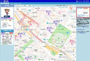
(1) Scale
(2) Switching Background Map
Basic actions such as sliding maps, enlargement / reduction, and displaying aerial photographs are the same as regular Google Maps.
Display contents
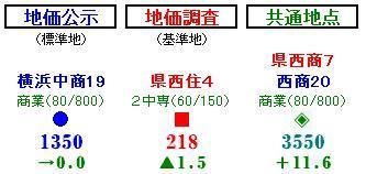
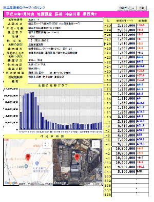
(1) Land Price Announcement (Standard Land): As of January 1
(2) Land price survey (reference land): As of July 1
(3) Common points of land price announcement and land price survey
The display contents indicate "point name (common point name under two-tiered writing)", "restricted area (building ratio / floor area ratio)", "approximate place", "price: 1,000 yen / square meter", and "variability rate" from the top. . (The items to be displayed automatically change depending on the scale of the map to be displayed.)
In the point name, "resident" indicates residential area, "commercial" refers to commercial area, "construction" refers to industrial area, "view" refers to expected residential land, and "forest" indicates forest land in the urbanization adjustment area.
Data selection
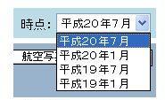
(1) Display year switching function
You can view past land prices by selecting the year and month from the pull-down menu at the top right of the screen.
(January is a land price announcement, July is a prefectural land price survey.)
Display of details screen
(1) To display the details screen
Click "●", "■" and "◆" displayed on the map with the mouse to display detailed land price data on another screen.
(2) Data of the Ministry of Land, Infrastructure, Transport and Tourism
Click the "Link to the Ministry of Land, Infrastructure, Transport and Tourism page" at the top left of the details screen with the mouse, and the detailed land price data of the Ministry of Land, Infrastructure, Transport and Tourism will be displayed on another screen.
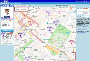
(3) Nearby Guide Map
The point you clicked is displayed in the center of the map.
Basic data and updates
(1) Basic data
The "Yokohama Land Price Map" is created using the data of land price announcements and prefectural land price surveys in the national land number information download service provided by the Ministry of Land, Infrastructure, Transport and Tourism, and data provided by Kanagawa Prefecture. .
(2) Date of renewal
Since the update work will be performed after obtaining data from the national and Kanagawa prefectures, the standard of the renewal date will be approximately two months from the date of publication of the land price announcement and the prefectural land price survey.
Operational help
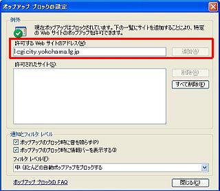
(1) When the details screen (pop-up screen) is not displayed
If the pop-up window is not displayed (the pop-up block function is enabled), you need to allow the pop-up.
A. From the InternetExplorer menu, "Tools" → "pop-up block" → Select "Settings pop-up block".
B. Enter "cgi.city.yokohama.lg.jp" in "Address of the website you want to allow" and press "Add".
C. Make sure that "cgi.city.yokohama.lg.jp" has been added to "Allowed Sites", and press "Close".
(2) When the map is not displayed while it is loaded
If the map is not displayed as read due to the environment of the PC used, the map is not displayed as it is loaded.
"GoogleMap" will not be displayed correctly unless "Unicode (UTF-8)" is selected, so select "Unicode (UTF-8)" from "View" and "Encoding" on the browser screen.
When "Encoding" is correct
(InternetExplorer) Select "Tools" and "Internet Options", and click "Delete" in the "General" tab "Browsing History". Execute the deletion of files and cookies.
Inquiries to this page
Planning Division, Urban Development Bureau Planning Department
Telephone: 045-671-3953
Telephone: 045-671-3953
Fax: 045-664-4539
Email address: tb-kokudo@city.yokohama.jp
Page ID: 911-781-186


