


- Yokohama-shi Top Page
- Living and Procedures
- Community Development and Environment
- Urban Development
- District planning, building agreements, etc.
- District planning
- District planning for each ward
- Nishi Ward
- C-106: Excite Yokohama 22 Yokohama Station Minami East Exit Area
Here's the text.
C-106: Excite Yokohama 22 Yokohama Station Minami East Exit Area
※The plan reads out statutory books in the form of a table, and it may be difficult to understand the contents. Please contact the Urban Revitalization Division for confirmation of the contents (Phone number: 045-671-2693)
Last Updated April 1, 2023
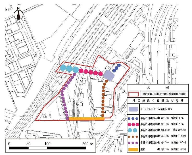
Plan drawing
| Name | Excite Yokohama 22 Yokohama Station Minami Higashiguchi District Planning | |
|---|---|---|
| Position | 2-chome, Takashima, Nishi-ku | |
| Area | About 2.5 ha | |
| Targets of District Planning | This area is located on the southeast side of Yokohama Station and faces the Katabira River. It is also adjacent to the Minato Mirai 21 and Hiranuma districts across the Katabira River. Although commercial and business facilities, warehouses, railway facilities, etc. are located in this area, the area is divided by railway, there are many low and unused areas, and land use is made taking advantage of the location characteristics near the station. It is not a situation. In addition, there are issues in accessibility to the adjacent Minato Mirai 21 district and Hiranuma district and the ease of migration in the district. Regarding the area around Yokohama Station, including this area, the overall concept of the Yokohama City Urban Planning Master Plan maximizes the potential of one of the largest number of passengers in the Tokyo metropolitan area and commercial agglomeration in front of the station, as well as the proximity to Haneda Airport, which has international competitiveness, and aims to use land to strengthen tourism and exchange functions. In addition, the Yokohama City Central Coastal Rehabilitation Master Plan states that it will strengthen and expand attractive pedestrian networks in order to attract people to the border line, which symbolizes Yokohama's uniqueness, and to strengthen cooperation between the coastal areas of the city center. Excite Yokohama 22 was formulated in 2009 by the cooperation of the private sector and the government around Yokohama Station, and as a future image of the town, a `` chosen town '' that invites people from around the world, a comfortable and memorable scene The "fascination town" is a place where everyone involved in the town advocates "a town that is proud of". Based on these future visions, build a three-dimensional pedestrian network that can move and travel east and west of Yokohama Station in an integrated and smooth manner, reorganize the station square that strengthens the airport access function at the east exit of Yokohama Station as a gateway to international bases In addition to the development of roads that will serve as frameworks to facilitate traffic in the area around Yokohama Station, and the development of rivers, sewers, and town development to ensure flood control safety appropriate for the area. Based on these, the Area Plan will appropriately guide private development projects planned in the Area, strengthen cooperation with each area in the coastal area of the city center and improve the migration around Yokohama Station, The goal is to create an attractive and lively urban space suitable for the city center by accumulating advanced commercial and business functions that meet the diverse needs of the city center, thereby realizing an attractive and lively urban space suitable for the entrance of the international city of Yokohama. |
|
| Ward Areas No 1. Bill ・ Opening Departure Oh Bi Hoping All Ni Seki S L Sir Needle |
Land Use Policy | 1 In order to create an attractive and lively urban space suitable for the gateway to the international city of Yokohama, we will promote advanced use of land and accumulate commercial and business functions that meet diverse needs in Japan and overseas. 2 We will build a three-dimensional pedestrian network consisting of decks centered on terminal cores, ground, and underground levels, thereby contributing to the smooth movement and migration around Yokohama Station. 3 Implement inundation measures in cooperation with rivers, sewers, and community development to create a safe and secure space. |
| Policy for the development of district facilities | While strengthening cooperation within the coastal area of the city center such as the Minato Mirai 21 district, secure the migration around Yokohama Station where commercial and business functions are highly concentrated, and build a highly convenient three-dimensional pedestrian network centered on the terminal core. 1 As a node of the pedestrian network, a stairwell will create a continuous space that takes into account the visibility from each layer, and a terminal core that functions as a guide for visitors, etc. will be developed. In addition, a space that creates liveliness in each layer will be maintained around the stairwell. 2 As routes that can cross the east and west of Yokohama Station, pedestrian passage A, terminal core, pedestrian passage B, and pedestrian passage C, which are directly connected to the underground shopping center at the east exit of Yokohama Station, will be continuously maintained, and the JR line south ticket gate Connect to 3 As a pedestrian traffic line connecting the area around Yokohama Station and Minato Mirai 21, a pedestrian passage D will be developed at the location connecting the Katabira River crossing deck and the terminal core, and in cooperation with the architectural plan, a multi-layered and lively migration line will be formed. 4 As a pedestrian traffic line connecting the area around Yokohama Station and the Hiranuma area, a pedestrian passage E will be developed as part of the Toyoko Line site project, which is being developed from the Hiranuma area, and will be connected to the pedestrian passage B. Connect to the terminal core. 5 In order to enhance the ease of migration in the main area, pedestrian passage D, road, pedestrian passage E and pedestrian passage B will be developed as routes that can go around the area centering on the terminal core. |
|
| District maintenance plan | |||
|---|---|---|---|
Placement and scale of district facilities |
Terminal core |
Area approximately 500m2 (including non-blue sky, stairwell part) |
|
| Passage A for pedestrians Passage B for pedestrians Passage C for pedestrians Passage D for pedestrians A passage for pedestrians E |
Width 6.0m extension about 40m (non-blue sky) Width 9.0m extension about 70m (non-blue sky) Width 13.0m extension Approx. 50m (non-blue sky) Width 2.0m extension Approx. 100m (non-blue sky) Width 4.0m extension Approx. 120m (non-blue sky) |
||
| Roads | Width 4.0m extension about 120m | ||
Inquiries to this page
Urban Renewal Division, Urban Development Bureau Urban Renewal Department
Telephone: 045-671-2693
Telephone: 045-671-2693
Fax: 045-664-3551
Email address: tb-tosai@city.yokohama.lg.jp
Page ID: 546-442-087


