


Here's the text.
Area around Seya Station
Last Updated March 31, 2023
Notice
Overview of the District
The area around Seya Station is a district that has been promoting land readjustment projects and urban redevelopment projects in order to accumulate functions and improve urban infrastructure suitable as a regional base.
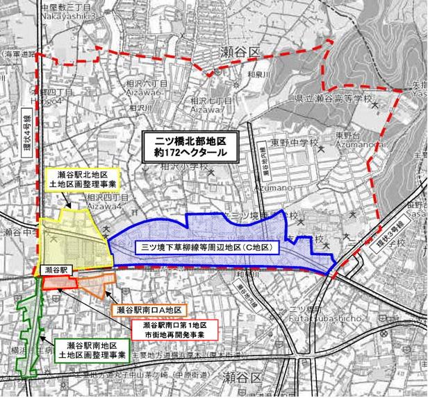
On the north side of Seya Station, in the northern part of Futatsu Bridge (approximately 172 hectares), a city plan was decided in 1958 as a district to promote land readjustment projects. Of these, in the northern area of Seya Station (approximately 8.9 hectares), a business plan for the land readjustment project was decided in 1988, and the project was completed in March 2000. . In the future, along with the "Thoughts of Town Development in the Northern Futatsu Bridge District (PDF: 992KB)" established in 2005 for the northern part of Futatsu Bridge, we will respond to the characteristics of the district without sticking to town development through land readjustment projects. We will continue to consider ways of town development.
⇒Please confirm here about the northern part of Futatsu Bridge (red line part shown below).
On the south side of Seya Station, we started a business as a roadside readjustment type street project in 1988 with the aim of maintaining Route 4, and the land readjustment project was completed in 1998. In addition, in order to realize a lively city, such as the development of urban infrastructure such as the station square and the accumulation of commercial facilities and urban-type houses suitable for the station square, the Seya Station South Exit Type 1 Urban Redevelopment Project was implemented. The redevelopment building was completed in September 2021.
In addition, around Seya Station, we will strengthen cooperation between the north and south of the station, aim to create a comfortable urban environment with a sense of unity centered on the station, and establish the `` Seya Station Area District District Plan '' In order to guide land use appropriate for the commercial area in front of the station, we have established the "Seya Station Area District Town Planning Consultation Guidelines" and are promoting town development.
Location map around Seya Station
Seya Station South Exit First District Type 1 Urban Redevelopment Project (Construction completed)
In the first district of the south exit of Seya Station (approximately 1.0 hectares), studies are being promoted toward the realization of a lively city, such as the development of urban infrastructure such as station squares and the accumulation of commercial facilities and urban-type houses suitable for the station square. On July 3, 2015, we made a city planning decision for "Seya Station South Exit First District Urban Redevelopment Project".
The union establishment approval (business plan approval) was made on December 5, 2016, and the business was promoted. The redevelopment building was completed in September 2021, and public facilities such as roads were completed in March 2022.
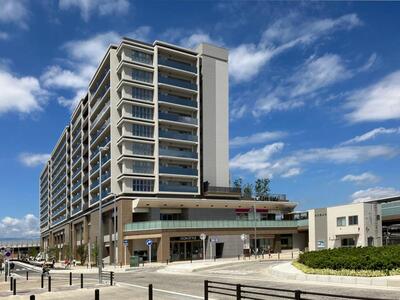 Redevelopment Building (Live Gate Seya)
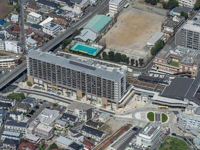 Aerial photograph
| Business name | Seya Station South Exit First District Type 1 Urban Redevelopment Project | |
|---|---|---|
| Enforcer | Seya Station South Exit District 1 Urban Redevelopment Association | |
| Enforced area | Approximately 1.0 hectares | |
| Effective period | From FY2016 to FY2016 | |
| City planning decision | July 3, 2015 | |
Business plan decision (initial) | December 5, 2016 (approved to establish a union) | |
| Public facilities, etc. | City planning road Seya Station South Exit Line width: 14m, extension: 120m (Includes about 3,000 m2 of station square.) | |
Facility buildings | Total floor area | Approx. 24,600㎡ |
Main Applications | Apartment houses, commercial facilities, public facilities (Citizens' Cultural Center), parking lots, etc. | |
| Number of floors | 1st basement floor, 10th floor above ground | |
Seya Station South District Land Readjustment Project (Roadside Land Readjustment Type Street Project) (Completion)
| Enforcer | Yokohama-shi |
|---|---|
| Enforced area | Approximately 3.2 hectares |
| Effective period | Fiscal 2008 - Fiscal 2008 |
| Operating expenses | Approx. ¥5.7 billion |
| Number of right holders | 47 people |
| City planning decision | August 5, 1988 |
| Business plan decision | December 5, 1988 (changed on March 25, 1998) |
| Landfill disposal | August 5, 1998 |
| Reduction rate | About 15% |
| Land Use Plan | About 12,900 square meters of public land Residential land approximately 19,000 square meters |
| Facility plan | Urban planning roads (Ring Route 4, Yokohama Atsugi Line) Blocked streets, supply processing facilities |
District planning
Town planning consultation
Town planning consultation district system
Seya Station Area Community Development Consultation Guidelines
You may need a separate PDF reader to open a PDF file.
If you do not have it, you can download it free of charge from Adobe.
![]() To download Adobe Acrobat Reader DC
To download Adobe Acrobat Reader DC
Inquiries to this page
Urban Development Promotion Division, Urban Development Bureau Urban Development Department
Telephone: 045-671-4009
Telephone: 045-671-4009
Fax: 045-664-7694
Email address: tb-seibisuishin@city.yokohama.lg.jp
Page ID: 458-025-198


