


- Yokohama-shi Top Page
- Hodogaya Ward Top Page
- Introduction of ward
- Nature of Hodogaya Ward
- Green axes (walking route)
- Walking route to enjoy the rich greenery of Hodogaya Ward [Nishiya Water Purification Plant-Imai Bridge Route]
Here's the text.
Walking route to enjoy the rich greenery of Hodogaya Ward [Nishiya Water Purification Plant-Imai Bridge Route]
Last Updated February 16, 2024
Nishiya Water Purification Plant-Imai Bridge Route (distance about 2.9 km, travel time about 44 minutes)
※In this section, information signs are undeveloped. Please be careful.
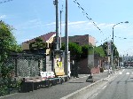
| Cumulative distance 0.0km, travel time 0 minutes | 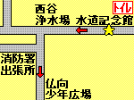 |
|---|---|---|
| Cumulative distance of about 0.9 km, travel time about 14 minutes After passing the Buddhist Youth Square, be careful on your right hand and find a side road. It's hard to understand here, so be careful not to make a mistake. | 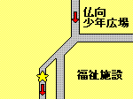 |
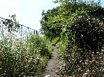
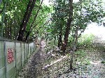
| Cumulative distance of about 1.0km, travel time about 15 minutes After passing the side road, enter the forest and proceed along the left wall. | 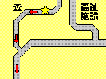 |
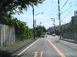
| Cumulative distance: 1.6km, travel time is about 24 minutes After passing through the forest, turn left and head toward Shin-Sakuragaoka. You can see the greenery of Bukkoucho on your left. | 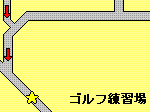 |
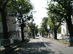
| Cumulative distance is about 1.9km, travel time: 28 minutes Shin-Sakuragaoka, a beautiful street tree. If you go straight, the goal is right there. | 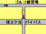 |
| Cumulative distance of about 2.9km, travel time: 44 minutes Goal! Thank you very much for your help.Check the timetable of the Sotetsu bus (outside site) (the nearest bus stop is "Imai Bridge" (for Hodogaya Station, Yokohama Station, Sakuragicho Station, Mitatebashi / Futamatagawa Station North Exit).) | 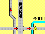 |
For inquiries to this page
Hodogaya Ward General Affairs Department Ward Administration Promotion Division Planning and Adjustment Section
Phone: 045-334-6228
Phone: 045-334-6228
Fax: 045-333-7945
Email address: ho-kikaku@city.yokohama.jp
Page ID: 676-467-951


