Walking route to enjoy the rich greenery of Hodogaya Ward [Nishiya Station-Nishiya Water Purification Plant Route]
Here's the text.
Walking route to enjoy the rich greenery of Hodogaya Ward [Nishiya Station-Nishiya Water Purification Plant Route]
Last Updated February 16, 2024
Nishiya Station-Nishiya Water Purification Plant Route (distance about 2.8 km, travel time about 43 minutes)
Walking route introduction
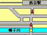
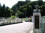
School bridge
Cumulative distance of about 0.2km, travel time about 3 minutes The school bridge over Katabira River. When you cross the river, you will see a green sign right there. The bronze statue of a small child on the bridge is also a must-see.
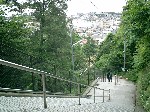
View from the top of the stairs
Cumulative distance of about 0.3km, travel time 5 minutes After crossing the school bridge, go through the narrow road in front of you and go up the stairs. It's a bit difficult, but if you turn back from the top, you can enjoy the view of Nishitani-cho.
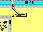
The Road leading to Kawashima Elementary School
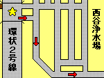
Cumulative distance of about 0.8km, travel time about 13 minutes After going up the stairs and passing Nishitani Junior High School, turn left. It's very difficult to understand here, so be careful not to make a mistake.
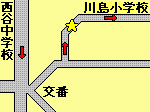
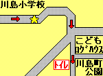
In front of Kawashima Elementary School
Cumulative distance is about 1.1km, travel time: 17 minutes Road in front of Kawashima Elementary School surrounded by elementary school greenery and forest greenery. This mysterious atmosphere lasts about 200m. The toilet is located in Kawajimacho Park beyond.
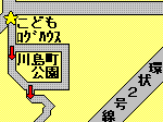
Children's log house
Cumulative distance is about 1.3km, travel time about 19 minutes After passing the road in front of Kawashima Elementary School and cross the pedestrian crossing, you will find a children's log house in front of you. Go through Kawajimacho Park in the back and head to Jingashita Keikoku Park.
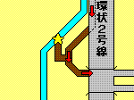
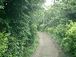
The road leading to Jingashita Keikoku Park
Cumulative distance: 1.6km, travel time is about 24 minutes Go through here and head to Jingashita Keikoku Park while enjoying the sound of the valley. Let's walk carefully because there are some bad feet in the future.
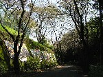
Jingashita Keikoku Park
Cumulative distance of about 1.8km, travel time about 27 minutes At Jingashita Keikoku Park, you can enjoy nature that is so rich that you can't imagine Route 2 is nearby.
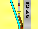
Jingashita tunnel
Cumulative distance is about 1.9km, travel time: 28 minutes After passing Jingashita Keikoku Park, cross the Jingashita Tunnel that crosses Route 2. If you cross here, you'll step up to the goal.
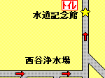
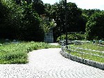
Yokohama Waterworks Memorial Hall
Cumulative distance is about 2.8 km, travel time is about 43 minutes Goal! Thank you very much for your help. Check the timetable of the Sotetsu bus (outside site) (the nearest bus stop is "Water Purification Plant" (Wadamachi Station / Yokohama-sta.-nishiguchi, Nishihara Housing / Tsurugamine Station, Shin-Sakuragaoka housing complex).)
For inquiries to this page
Hodogaya Ward General Affairs Department Ward Administration Promotion Division Planning and Adjustment Section