- Yokohama-shi Top Page
- Disaster prevention and emergency services
- Disaster Prevention and Disasters
- Be prepared in case of emergency
- Our Home Measures (self support)
- Earthquake
- Knowledge of earthquakes
- Earthquake memo ~ Let's know about earthquakes! ~
Here's the text.
Earthquake memo ~ Let's know about earthquakes! ~
Last Updated January 18, 2024
Based on the lessons learned from the Great Hanshin-Awaji Earthquake, Yokohama City has developed seismic observation facilities and developed them.
We are actively promoting earthquake analysis and research.
![]()
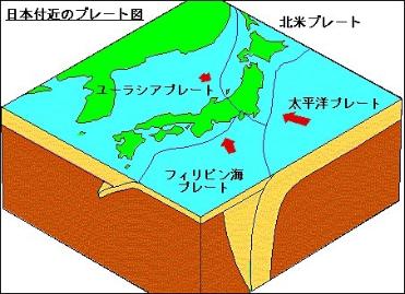
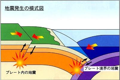
The surface of the earth is covered with more than a dozen plates (bedrock plates). Plates are moving in different directions several centimeters a year, depending on the convection motion of the mantle inside the Earth. At the boundary between plates, "strains" accumulate due to the sinking of the plate, and weak parts that cannot withstand this are destroyed, causing an earthquake. This is called the "earthquake at the plate boundary."
Also, inside the plate, force by plate motion is applied, and "strain" accumulates, and weak parts are destroyed, causing an earthquake. This is called the "earthquake in the plate". Earthquakes caused by the activities of the fault were one of them, and the Hyogoken Nanbu Earthquake and the Tottoriken Seibu Earthquake that caused the Great Hanshin-Awaji Earthquake were caused by the fault Movement in shallow land areas.


◆Related Websites
・Exploring the mechanism of earthquake occurrence (outside site)
・Earthquake Activities in Japan (outside site)
![]()
Both magnitude and seismic intensity are scales that represent the strength of earthquakes, and these two are often mistaken. magnitude is a figure representing the magnitude of the earthquake itself that caused the ground shaking. On the other hand, seismic intensity is "strength of shaking in various places caused by earthquakes", and is expressed in ten levels from seismic intensity 0 to 7.
In seismic intensity, published by the Japan Meteorological Agency, observers at meteorological stations and weather stations used to determine actual shaking conditions, but now they automatically calculate seismic intensity from the seismic intensity Metrology System. If magnitude is the number of watts of light bulbs, seismic intensity is the brightness of the desk. The brightness on the desk becomes brighter as the number of watts of the light bulb is larger, but even with the same light bulb, it is brighter than far away near the light bulb.
About seismic intensity [link to Japan Meteorological Agency] (outside site)
![]()
Strain accumulates in the crust due to collision of plates, etc., resulting in a displacement of rock in order to eliminate the strain in the crust, and it was fault that appeared on the ground surface. In the new edition of the active fault of Japan, a compilation of Japanese active fault data, active fault is based on fault, where it is estimated that earthquakes will occur repeatedly in the future.
It is said that there are about 2,000 active faults in the Japanese Islands. About 30 active faults have been identified in Kanagawa Prefecture, but no active fault has been identified in Yokohama. However, since there are frequent occurrences of micro-quakes near the border with Kawasaki City, and steps are estimated to be deep underground in Yokohama City, which is believed to be located in the extension of Tachikawa fault, active fault. As a result, it was confirmed that the Tachikawa fault, active fault, did not extend to the city of Yokohama.
◆Related Websites
・Active fault surveys in various parts of Japan (outside site)
![]()
Based on the lessons learned from the Great Hanshin-Awaji Earthquake, Yokohama City is actively promoting the development of earthquake observation facilities in the city and the analysis of earthquakes. Since 1997, we have been conducting full-scale seismic observations using the "High Density Strong Seismic Meter Network", which has installed 150 seismometers in the city area, in order to convey earthquake information to citizens faster and more accurately. The observation results so far have shown that the magnitude of the shaking varies depending on the region in the city. This is because not only the ground where the seismometer is installed is different, but also the shape of the hard rock called the "earthquake base" in the deep underground is not uniform.
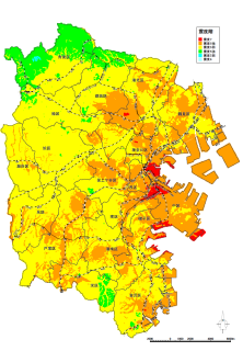
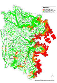
Therefore, we conducted a survey on the underground structure in the city from 1998 to 2000. Investigations so far have shown that the depth of the earthquake base in Yokohama City has considerable irregularities from about 2.5 km to about 4 km. In addition, it was confirmed that there was a step structure in which the earthquake base in the southern part of Aoba Ward was about 1 km deep toward the north, and it was estimated that it would run east and west. Based on the results of these surveys, we created an "earthquake map" and a "liquefaction map" that show "where in the city area shakes" for multiple assumed earthquakes. . This map will provide information to citizens and companies, and will be used for disaster prevention measures.


Earthquake map showing distribution of seismic intensity "Liquefaction Map" that estimates liquefaction
◆Related Websites
・Underground structure survey in various parts of Japan (outside site)
・Earthquake Information in Yokohama City
◆Link of earthquake-related information
・Ministry of Education, Culture, Sports, Science and Technology Earthquake Research Promotion Headquarters (outside site)
・Cabinet Office Disaster Prevention Information Page (outside site)
・Japan Meteorological Agency (outside site)
・Research Institute for Disaster Prevention Science and Technology (outside site)
・Geographical Survey Institute (outside site)
・Marine Information Department, Coast Guard Headquarters (external site)
・Earthquake Research Institute, The University of Tokyo (external site)
Inquiries to this page
Regional Disaster Prevention Section, General Affairs Bureau Crisis Management Department
Telephone: 045-671-2011
Telephone: 045-671-2011
Fax: 045-641-1677
Email address: so-chiikibousai@city.yokohama.lg.jp
Page ID: 441-382-942


