


- Yokohama-shi Top Page
- Disaster prevention and emergency services
- Disaster Prevention and Disasters
- Be prepared in case of emergency
- Our Home Measures (self support)
- Yokohama City Evacuation Navigation
Here's the text.
Yokohama City Evacuation Navigation
Use "Yokohama City Evacuation Navi" to prepare for "Iza" during normal times from "now"!
Last Updated October 19, 2023

What is "Yokohama City Evacuation Navigation"?
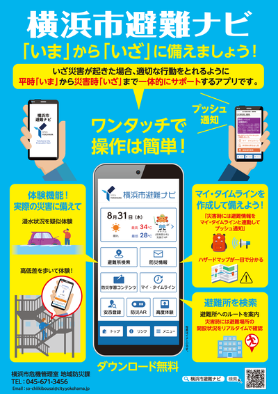
"Yokohama City Evacuation Navi" is an application that supports each individual's evacuation behavior in an integrated manner from "now" in normal times to "Iza" in times of disaster.
- Fostering awareness: You can use AR to simulate the event of flooding
- Pre-preparation: Check hazard maps and shelters, automatically determine the dangers of your current location, and create a My Timeline.
- Support for evacuation behavior: In the event of a disaster, evacuation information linked to the My Timeline is sent push notification to confirm the opened evacuation sites and routes.
Function introduction (video)
It was introduced on YouTube "Yokohama City Fire Music Band Absolute Band Channel"!
On the "Yokohama City Fire Music Band Absolute Band Channel", a scene where a member of the band tried using the advanced experience function of the Yokohama City Evacuation Navi while climbing the Yokohama Marine Tower etc. is uploaded, so please take a look from the following! In addition, we have posted a lot of other videos, so please check it out from the video summary column.♪
How to install
You can install it from each app store.
※Free download (communication fees, etc. for using the application will be borne by the user)
[iOS Version] iOS version download link (outside site)

[Android version] Android version download link (outside site)

How to create a My Timeline
Once you have installed Yokohama City Evacuation Navigation
First of all, let's create "My Timeline"!
How to create My Timeline (PDF) (PDF: 2,644KB)
[Reference]
My Timeline refers to disasters that may occur in the future, such as typhoons and heavy rains.
This is your own evacuation action plan organized in chronological order according to the family structure and local environment of each individual.
Know the risk of flooding in your area, and consider the timing of evacuation in the event of a disaster and evacuation behavior in advance.
Handbill
※The photograph is for illustrative purposes only.
Yokohama City Evacuation Navigation Flyer (PDF: 5,893KB)
In production
"Yokohama City Evacuation Navi" was produced by First Media Co., Ltd. and Kanagawa Dental University, which have knowledge of app production and AR technology, and Yokohama City, signed a three-party agreement.
Reference: Press release on March 8, 2022 "Product of" Yokohama City Evacuation Navi "through cooperation between industry, academia and government" (PDF: 1,097KB)
Notice
How to update
[ios Version]
Open App Store → Tap the profile icon at the top of the screen. → Scroll down to check the pending update etc. To update only "Yokohama City Evacuation Navi", tap "Update" next to it.
[Android version]
Open Google Store → Open the profile icon at the top right of the screen. → Open Apps and Device Management → Select "Yokohama City Evacuation Navigation" from the apps that can be updated and tap [Update].
Problems in which information on other cities is transmitted
In order to resolve the problem in which information on other cities is transmitted, please upgrade the version.
Update information
・【NEW】 Advanced experience function has been added.
・The layout has been updated.
Related link
Japan Meteorological Agency "Kikuru" (outside site)
Yokohama-shi flood disaster information (outside site)
You may need a separate PDF reader to open a PDF file.
If you do not have it, you can download it free of charge from Adobe.
![]() To download Adobe Acrobat Reader DC
To download Adobe Acrobat Reader DC
Inquiries to this page
Regional Disaster Prevention Section, General Affairs Bureau Crisis Management Department
Telephone: 045-671-3456
Telephone: 045-671-3456
Fax: 045-641-1677
Email address: so-chiikibousai@city.yokohama.lg.jp
Page ID: 224-471-345


