


- Yokohama-shi Top Page
- Tsuzuki Ward Top Page
- Living and Procedures
- Community Development and Environment
- Green eco
- Tsuzuki Ward Water and Green Walking Map
- Tsuzuki Ward Water and Green Walking Map (North and Southern Integrated Version)
Here's the text.
Tsuzuki Ward Water and Green Walking Map (North and Southern Integrated Version)
Last Updated June 4, 2024
About the stroll map of the renewal version
Sales of the renewed version began on June 3, 2024.
From this time, "3rd generation Wataru Nakayama Saburo" was newly introduced to "People related to Tsuzuki" (p39), and "Wataru Nakayama Saburo Family (Yokohama City Certified Historic Building)" was added to Course I (p24-p25), and "Wataru Nakayama Saburo Family (Yokohama City Certified Historic Building)" was added to the map surface and back cover, making it easier for easier for everyone to use.
Sales location
・Tsuzuki Ward Office 1F Store
・Yokohama City Hall 3F Municipal Government Publications and Goods Sales Corner
※ The “Municipal Government Publications and Goods Sales Corner”![]() also sells by mail.
also sells by mail.
Sales time
From 9:00 to 17:00 (excluding holidays and holidays)
Sales price
400 yen (tax included)
Contents
- The height difference is expressed in color, and the height of the course is displayed.
- Easy-to-carry A4 folding bifold (water-repellent processing to prevent rain wetting on the front and back covers)
- A landscape and playground map of Tsuzuki where you can find the highlights, playgrounds, and view spots of flowers throughout the city.
- "People related to Tsuzuki" is posted.
- Introducing 15 walking courses and attractive spots starting and ending points at each municipal subway station and bus stop
Walking map data
- Cover and back cover (PDF: 1,741KB)
- Precautions for walking and walking, index (highlights, columns, people who are related to Tsuzuki) (PDF: 413KB)
- Introduction of 15 courses recommended by Tsuzuki (PDF: 1,681KB)
- Scenery and playground map of Tsuzuki (PDF: 2,030KB)
- Course A: The course that walks through Goyama and Hayabuchi River (Center-Kita Station-Center Minami Station) (PDF: 2,222KB)
- Course B: Course (Nakagawa Station-Nakagawa Station) that loves the flowers of Nakagawa and walks along the ridge road of Eda via the old Oyama Kaido (PDF: 2,285KB)
- Course C: Course to enjoy the distant view of Minato Mirai (Nakagawa Station-Nakagawa Station) (PDF: 2,204KB)
- Course D: Tour of Zodiac Stone Search and Shrines and Temples (Kitayamada Station-Kitayamada Station) (PDF: 2,140KB)
- E Course: Course to touch the history of Yamada Fuji and hometown (Higashiyamada Station-Higashiyamada Station) (PDF: 2,172KB)
- F Course: Course that walks now in memory of the old days of Kawawa-juku (Tsuzuki Fureai no Oka Station-Kawawacho Station) (PDF: 2,205KB)
- G Course: Course (Tsuzuki Fureai no Oka Station-Kawawacho Station) walking through Kawawa Citizen's Forest from Kawawa Fuji (PDF: 2,180KB)
- H Course: Course around the shrines and temples of Ikebe and Tando (Tsuzuki Fureai no Oka Station-La La Port Yokohama) (PDF: 2,214KB)
- Course I: A course to visit the history of Kawawa and Saedo and walk along the Tsurumi River (Kawawacho Station-Kawawacho Station) (PDF: 2,153KB)
- J Course: Course to enjoy the present and old days of New Town (Nakamachidai Station-Nakamachidai Station) (PDF: 2,237KB)
- K Course: Course (Nakamachidai Station-Nakamachidai Station) walking along the hydrangea green path around the original scenery of Tsuzuki (PDF: 2,107KB)
- L Course: Course to enjoy panorama of bamboo grove and plateau in the east (Nakamachidai Station-Nakamachidai Station-Ikebe Bus Stop) (PDF: 2,241KB)
- M Course: Course to enjoy the view from Orimoto farmland and the Egawa murmuring green road (Nakamachidai Station-Higashigatacho bus stop) (PDF: 2,126KB)
- Course N: Course (Nakamachidai Station-Tsuzuki Fureai no Oka Station) that walks on a green road rich in nature at ease (PDF: 3,063KB)
- O Course: Course around Tsuzuki Vegetable Field (Nakamachidai Station-Tsuzuki Fureai no Oka Station) (PDF: 1,443KB)
- Person who is related to Tsuzuki (PDF: 1,842KB)
Requests to everyone who enjoys a walk

Be sure to follow the manners when you take a walk.
・Be sure to take your trash home.
・Let's stop walking tobacco.
・Never take flowers or creatures.
・Let's use the public toilet cleanly.
※When using the toilet installed in the facility on the route, ask the facility to speak.
Thank you for your consideration.
・Don't enter private land without permission.
・When taking a photo, consider your privacy.
・Don't spread when walking in a group.
※When walking in a group, ensure a certain distance, and take thorough infection prevention measures such as wearing a mask, cough etiquette, and hand washing.
・Follow traffic rules and be careful when crossing the road.
・When visiting the facility, follow the manners that were there.
History of Creation
In commemoration of the 20th anniversary of the constituency system, the Tsuzuki Ward Water and Green Walking Map was published to encourage new residents and visitors to Tsuzuki from outside the ward to learn about Tsuzuki Ward 's precious water and green environmental resources and historical temples and shrines, and to encourageTsuzuki Ward residents to discover new things.
In addition to unifying the specifications of the existing Tsuzuki Ward Southern Water and Green Walking Map and the Northern Tsuzuki Ward Water and Green Walking Map, we conducted field surveys and examinations while adding new walking courses and attractive spots.
In issuing this map, we were very grateful to the people involved, such as the kind and courteous response in the local area, the provision of permission to publish and commentary. Thank you very much.

Study Group
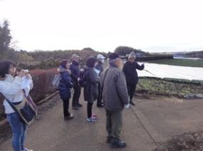
Field survey
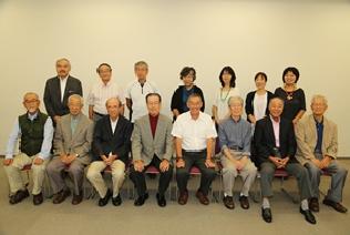
Member of Tsuzuki Ward Water and Green Walking Map Creation Study Group
You may need a separate PDF reader to open a PDF file.
If you do not have it, you can download it free of charge from Adobe.
![]() To download Adobe Acrobat Reader DC
To download Adobe Acrobat Reader DC
Inquiries to this page
Tsuzuki Ward Ward Administration Promotion Division Planning and Adjustment Section
Telephone: 045-948-2225,045-948-2226
Telephone: 045-948-2225,045-948-2226
Fax: 045-948-2399
Email address: tz-plan@city.yokohama.jp
Page ID: 168-647-665


