- Yokohama-shi Top Page
- Tsurumi Ward Top Page
- Introduction of the ward
- Overview of Tsurumi Ward
- History of Tsurumi Ward
- 14th: Historic Sites and Legends of Tsurumi
Here's the text.
14th: Historic Sites and Legends of Tsurumi
Last Updated July 9, 2024
Nike Irrigation Water
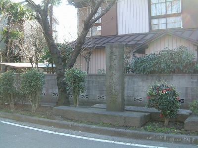
The nameplate of the bridge of the "Meotobashi" in the market and the monument of the "Nikkaryo Irrigation Canal Site"
A small bridge nameplate marked "Marubeni Bridge" is left on the cornerstone of the block wall of Kumagaya liquor store facing the bus street of Ichiba Kamimachi 6-chome.
There were two large and small irrigation moats at the border between Kanagawa-juku and Kawasaki-juku in the Tokaido Market Village during the Edo period. It was called Shiota moat that flows toward Shiota and Ichiba moat that flows toward the market. The couple bridge is the name of two large and small stone bridges that were hung on these two irrigation moats.
The main stream of the two moats was Nikka territory water drawn in from the Tama River, and clean water was flowing steadily. The shallow and deep flow was also a great place for travelers traveling along the Tokaido to wash away sweat and dust.
The Nikkaryo Irrigation Water was excavated by the water magistrate Tsutayu Koizumi, who was ordered by Ieyasu Tokugawa to flood control and develop Nitta in the rampage river Tama River, which repeatedly floods every year. Surveying began in 1597 (1597), and two years later, excavation work began. The 32-kilometer-long irrigation canal, which was carried out with the cooperation of many farmers, was completed in 1611 (Keicho era 16) over 15 years after the start of surveying. 37 villages in Inage territory and 23 villages in Kawasaki territory, a total of 60 villages in 2,700 town steps (199 hectares), an irrigation canal stretched like a net, and the two territory of Inage territory and Kawasaki territory were moistened. Was given. Tsujita Koizumi also started and completed the construction of Rokugo irrigation water in Setagaya and Rokugo on the opposite bank, so these two irrigation waters were also called "Shikoku irrigation water." The Yako district, a market near Kawasaki across the Tsurumi River, belonged to the Kawasaki territory during the Edo period, so it benefited from two territorial waters.
The Tsurumi area merged with Yokohama City in 1927 (Showa 2), and water supply was laid in Shiota, Market, and Yako districts. The coastal area of Tsurumi was reclaimed and the Keihin Industrial Zone was formed, and the farmland was transformed into residential land and factory land. Nikkaryo Irrigation Water was also used as industrial water, but the water supply became widespread, and it was reclaimed as having finished its role as agricultural water and domestic water, and most of it was transformed into roads.
"The water in the Tsurumi River contained salt because seawater flowed backwards, so it could not be used for paddy fields or domestic water." Thanks to the Nikkaryo irrigation water, the rice fields around here were moisturized. The rice in the rice field irrigated by this water was very delicious. In the Edo period, the rice that can be obtained in this basin was high-quality rice called Inage rice, which was sushi rice from Edo Castle. Even after the war, clean water was flowing steadily, and people who lived near the irrigation moat washed vegetables and picked rice in this moat. Factories and houses have been built, rice fields and fields have disappeared, and water has been buried and turned into roads," said an old market man 10 years ago. Now there is almost no one who can tell him about it. From the intersection in front of the Kumagaya liquor store to the Keikyu railway track, two large and small roads are divided into Y-shaped, and the remnants of the former waterway are slightly preserved.
There is a monument to "Nikkaryo Irrigation Canal Site" in Yamu, Tsurumi-ku. This monument was reclaimed by the people of the Yako district in 1972 (Showa 47), and was rebuilt on roads and green belts, and was built over the Nikkaryo Irrigation Canal. It was built by reusing it.
The front of the monument is engraved with "Nikkaryo Irrigation Canal Site", and the back is engraved with "November 2550 AD, 1893, Machimura Yamugai Shimogo Villages". Both the Meoto Bridge and the Yako Ishibashi Bridge were rebuilt during the Meiji era (see Figure 2).
Reference Materials: "Historic Sites and Legends of Tsurumi"

Figure 2: Yako's two-territorial Canal
Inquiries to this page
Tsurumi Ward General Affairs Department Ward Administration Promotion Division
Telephone: 045-510-1680
Telephone: 045-510-1680
Fax: 045-510-1891
Email address: tr-kusei@city.yokohama.lg.jp
Page ID: 564-616-536


