


- Yokohama-shi Top Page
- Nishi Ward Top Page
- Introduction of the ward
- Sightseeing
- Recommended course
- History walk
- Overview of the History of Nishi Ward
Here's the text.
Overview of the History of Nishi Ward
Last Updated January 17, 2019
Download of brochure (PDF: 5,211KB)
※This booklet has not been distributed. Thank you for your understanding.
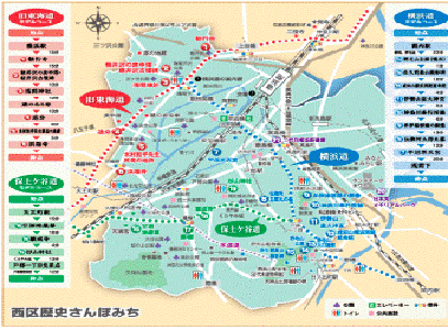
Old Tokaido
In the past, from the current area around Yokohama Station to Kubocho, it was an inner bay called Sodegaura. The old Tokaido was connected from Kanagawa-juku to Hodogaya-juku along the sea (currently from Kusunoki-cho to Sengencho). The area was famous as a very scenic place, with white sails floating in a quiet cove.
During the Edo period, there was a position between the inn and the inn along the highway as a resting place for people and horses. The lawn village (Shibomura / current Sengencho) between Kanagawa-juku and Hodogaya-juku was developed in this position, and in addition to the farm, commerce such as selling Iiya, sake and straw was also engaged in commerce.
See the details of the Old Tokaido
Yokohama way
In June 1858, the Shogunate decided to open Kanagawa (Yokohama) in June 1858, with the signing of the Japan-US Osamu Treaty of Commerce and Trade.
However, the city planning of Minato Yokohama was finally started in March, three months before the opening of the port. At that time, transportation from the Tokai route to Yokohama was very inconvenient, so the Shogunate opened a road called "Yokohama way" from Shibamura on the Tokai route (near the current Sengencho intersection) to Yokohama (Kannai). (At that time, the only way to contact the Tokaido was to pass from Hodogaya through Idogaya or Maita, or by boat from Kanagawa.)
This road builds a straight road from the lawn village through the wetlands of Okano and Hiranuma to Tobe Village, and also builds three bridges between Nitta, Hiranuma, and Ishizaki. The Otage Bridge (now Yoshidabashi Bridge) and Noge Bridge (Miyakobashi Bridge Bridge).
According to records, the width of the bridge at that time was three (less than 6m), and the road was probably equivalent to this. During the construction period of three months, the bridge was made of cedar for the balustrade and pine for the stake.
This path, which flourished as a major road to Shinkaichi Yokohama, has changed drastically with the passage of times, and now only slightly retains the impression of living.
See the details of Yokohama way
Hodogaya Road
Hodogaya Road was used for traffic between Tobe Village and Hodogaya-juku. This road passes through Kurayamizaka from Koshin Pagoda at Inari Shrine in Tobecho, turns left at Nishimaecho intersection, goes to Ganjoji Monzen, passes through the Fujidana district shopping street, crosses the JR Tokaido Line, and joins the Tokaido on Daimon Street, Iwamacho, Iwamacho, Hodogaya-ku.
To the east of Inari Shrine in Tobecho, he went down Nogezaka through Noge cut-through and reached Nogeura.
See the details of "Hodogaya Road"
Maintenance of information signs
Along the above three old roads, we proceeded with maintenance based on opinions from inhabitants of a ward.
You may need a separate PDF reader to open a PDF file.
If you do not have it, you can download it free of charge from Adobe.
![]() To download Adobe Acrobat Reader DC
To download Adobe Acrobat Reader DC
Inquiries to this page
Nishi Ward General Affairs Department Regional Promotion Division
Telephone: 045-320-8389
Telephone: 045-320-8389
Fax: 045-322-5063
Email address: ni-chiikishinko@city.yokohama.lg.jp
Page ID: 881-876-314


