- Yokohama-shi Top Page
- Midori Ward Top Page
- Living and Procedures
- Community Development and Environment
- Town development
- Signs common to Tsurumi River basin (Midori Ward)
Here's the text.
Signs common to Tsurumi River basin (Midori Ward)
Last Updated November 11, 2024
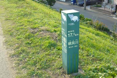
Common signs that are convenient for walking and running along the Tsurumi River are installed in common to the five wards of the basin.
The Tsurumi River, which runs through the five wards (Tsurumi Ward, Kohoku Ward, Midori Ward, Aoba Ward and Tsuzuki Ward ) in the eastern and northern parts of the city, is approximately 42.5 kilometers away from the full marathon. Along the river, there are many citizens who enjoy walking and running due to growing interest in the natural environment and the purpose of promoting health.
The purpose of this common sign is to introduce such citizens to the location of the Tsurumi River, information on surrounding flora and fauna, local attractive facilities, etc., and to guide them so that they can enjoy walking around the Tsurumi River. In setting up, we summarized contents and design based on opinion of river manager and civic group working in Tsurumi River basin.
Do you not visit Tsurumi River by all means for health promotion, nature observation?

Signpost (the distance from the estuary or confluence)
| Number | Installation location | Distance from the estuary or confluence |
|---|---|---|
| 1 | 4717, Ikonobecho, Tsuzuki-ku land | 17.5 kilometers from the mouth of the river |
| 2 | 4587-2, Ikonobecho, Tsuzuki-ku land | 18.0 kilometers from the mouth of the river |
| 3 | 600-4, Saedocho, Tsuzuki-ku land | 18.5 kilometers from the mouth of the river |
| 4 | 115-6, Niiharucho, Midori-ku land | 2.0 kilometers from the confluence |
| 5 | 38-5, Tookaichibacho, Midori-ku land | 3.0 kilometers from the confluence |
| 6 | 10-3, Tookaichibacho, Midori-ku land | 4.0 kilometers from the confluence |
| 7 | 1-29, Nagatsuta, Midori-ku land | 5.0 kilometers from the confluence |
| 8 | 2-46, Nagatsuta, Midori-ku land | 5.5 kilometers from the confluence |
| 9 | 2-20, Nagatsuta, Midori-ku land | 5.8 kilometers from the confluence |
10 | 2469, Nagatsutacho, Midori-ku land | 7.0 kilometers from the confluence |
Regional information board (guiding the surrounding map)
| Number | Installation location | Distance from the estuary or confluence |
|---|---|---|
| 1 | 56-3, Kamoicho, Midori-ku land | 18.1 kilometers from the mouth of the river |
| 2 | 1246-1, Nakayamacho, Midori-ku land | 0.0 kilometers from the confluence |
| 3 | 111-7, Niiharucho, Midori-ku land | 2.1 km from the confluence point |
| 4 | 82-6, Ibukino, Midori-ku land | 4.7 kilometers from the confluence |
[Contact for signs common to Tsurumi River basin]
Midori Ward Office Ward Administration Promotion Division Planning and Adjustment Section TEL045-930-2217
Tsurumi Ward Office Ward Administration Promotion Division Planning and Adjustment Section TEL045-510-1676
Kohoku Ward Office Ward Administration Promotion Division Planning and Adjustment Section TEL045-540-2229
Tsuzuki Ward Office Ward Administration Promotion Division Planning and Adjustment Section TEL045-948-2227
Aoba Ward Office Ward Administration Promotion Division Planning and Adjustment Section TEL045-978-2217
Inquiries to this page
Midori Ward General Affairs Department Ward Administration Promotion Division Public Relations Section
Telephone: 045-930-2217
Telephone: 045-930-2217
Fax: 045-930-2225
Email address: md-kikaku@city.yokohama.lg.jp
Page ID: 395-834-238


