


- Yokohama-shi Top Page
- Living and Procedures
- Community Development and Environment
- Urban Development
- District planning, building agreements, etc.
- District planning
- District planning for each ward
- Tsurumi Ward
- C-066: Tsurumi Shiota / Honchodori Streetscape Guidance Area
Here's the text.
C-066: Tsurumi Shiota / Honchodori Streetscape Guidance Area
※The plan reads out statutory books in the form of a table, and it may be difficult to understand the contents. Please refer to disaster prevention town development promotion section for confirmation of contents (Phone number: 045-671-3595)
Last Updated November 1, 2021
[Relaxation of floor area ratio restricted from front road width and road diagonal line restriction]
In area, we can receive relaxation within range that we established in district maintenance plan about floor area ratio and road diagonal line restriction restricted from width of front road by authorization procedure. For details, please refer to pages 5 and 6.
Tsurumi Shiota, Honchodori streetscape guidance district city planning handbook (PDF: 1,493KB)
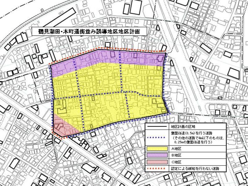
Plan drawing
| Name | Tsurumi Shiota / Honchodori Streetscape Guidance District District Planning | |
|---|---|---|
| Position | Shioda-cho, Tsurumi-ku, Yokohama-shi and Honchodori | |
| Area | About 3.7ha | |
| Ward Areas No 1. Bill ・ Opening Departure Oh Bi Hoping All No Sir Needle |
Targets of District Planning | This area is located about 0.7 km south of Tsurumi Station and southeast of Tsurumi River, and is a pre-war residential area close to the Keihin Industrial Area. Due to the rapid urbanization after the war and the rapid urbanization after the war, this area has formed an urban area with densely populated wooden houses, narrowing the buildings along with the aging of buildings, problems with disaster prevention such as undeveloped roads, ventilation, sunshine, etc. Have a problem. In addition, there are many small sites and rebuilding is not progressing. In this district plan, we promote safe and moist town development by promoting rebuilding and planning improvement of earthquake resistance such as buildings and prevention of fire spread by non-combustible, widening of road and promotion of greening The goal is. |
| Land Use Policy | In order to improve disaster prevention and living environment, we plan rebuilding to non-combustible houses, etc., and plan the formation of a spacious road space by narrowing and widening roads. In particular, along the roads that form the framework of the district will be promoted as a space that has the effect of suppressing the spread of fire in the event of a disaster, as well as a spacious space. | |
| Policy for regulation and guidance of buildings | In order to achieve the goals of this area through rebuilding of buildings, etc., we will regulate the form of buildings necessary. In addition, along roads with a width of less than 7m, within the designated floor area ratio, the approval of a specific administrative agency based on Article 68-5, Paragraph 1 of the Building Standards Act and Article 2, Paragraph 2 of the same Article, and the designated building In areas with a ratio of 60%, the permission of a specific administrative agency based on Article 53, Paragraph 4 of the Act will be used, and rebuilding of the rebuilding of the same law to guide to non-combustible buildings centered on low-rise houses. For this reason, the maximum floor area ratio of the building, the minimum floor area of the building, the limit of the position of the wall, the maximum height of the building, the restriction of the installation of the structure in the retreat area of the wall, and the structure of the fence or fence Defines restrictions. |
|
| Greening Policy | We plan active greening of roadside and residential land and try for formation of green residential district. | |
| District maintenance plan | |||||
|---|---|---|---|---|---|
| Construction Construction Goods Etc. Ni Seki S L A matter Section |
Classification of district |
Name |
District A |
District B |
District C |
Area |
About 2.9ha |
Approx. 0.7ha |
0.1ha |
||
| Maximum floor area ratio of buildings | 20/10 | 30/10 | 40/10 Provided, however, that this shall not apply to buildings subject to Article 52, Paragraph 7 of the Building Standards Act (* Note 1). |
||
| Minimum site area of buildings | 50m2 |
||||
| Provided, however, that when this provision is stipulated, if the land currently used as a site of a building that does not conform to this provision or is used as a site of a building based on existing ownership or other rights, This shall not apply when all of the land that does not conform to the provisions is used as one site. | |||||
| Restrictions on the position of the wall |
|
The distance from the outer wall of the building or the surface of the pillar in place of this to the boundary of the road shown in the plan drawing shall be 0.5 m or more, and the distance to the boundary of other roads (excluding those with a width exceeding 4 m) shall be 0.25 m or more. | |||
| Maximum height of buildings |
|
The height of the building must not exceed 20m. | The height of the building must not exceed 31m. | ||
| Restrictions on the installation of structures in the wall retreat area | Do not install fences, fences, gates, signboards, etc. in areas where the position of the wall surface from the road boundary is restricted. Provided, however, that this shall not apply to roofs, eaves, telephone poles, etc. necessary for the public interest. |
||||
| Restrictions on the structure of a fence or fence | The structure of the fence or fence shall have hedges, fences and similar openness. However, this excludes gateposts and other similar items. | ||||
(Note 1) Due to the revision of the Building Standards Law, items have been shifted. It should be correct, Article 52, Paragraph 8 of the Building Standards Law.
You may need a separate PDF reader to open a PDF file.
If you do not have it, you can download it free of charge from Adobe.
![]() To download Adobe Acrobat Reader DC
To download Adobe Acrobat Reader DC
Inquiries to this page
Urban Development Bureau Disaster Prevention Town Development Promotion Office Disaster Prevention Town Development Promotion Section
Telephone: 045-671-3595
Telephone: 045-671-3595
Fax: 045-663-5225
Email address: tb-bousai@city.yokohama.lg.jp
Page ID: 851-910-846


