


Here's the text.
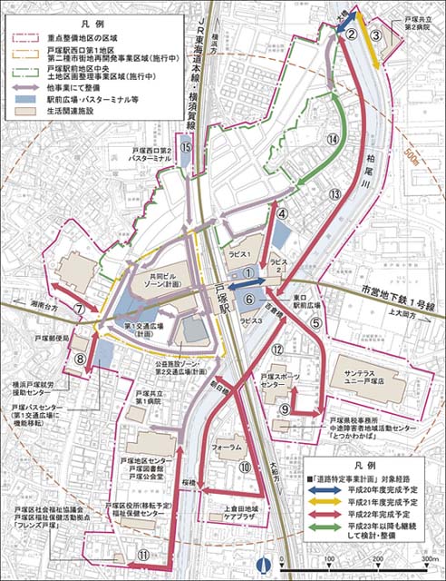
Totsuka Station Area Maintenance Status Map
Last Updated November 14, 2024
| Line name | Maintenance status |
|---|---|
| (1)Station East Exit pedestrian deck | Completed in FY 2008 |
| (2)National Route 1 (Large Railroad Crossing-Ohashi) | Completed in FY 2008 |
| (3)In front of Tozuka Kyoritsu No. 2 Hospital | Completed in FY 2008 |
| (4)(Tokyo) Kaminagaya Totsuka Line | Completed in FY2010 |
| (5)Prefectural Road Ofuna Station Yabe | Completed in FY2011 |
| (6)East Exit Station Square | Completed in fiscal 2009 |
| (7)Main local road Yokohama Isehara (Chogo Kaido) | Completed in FY2010 |
| (8)National Route 1 (Tokyo) Kashio Totsuka Line | Completed in FY2011 |
| (9)In front of Tozuka Sports Center | Completed in fiscal 2009 |
| (10)In front of Asahi Bridge to Kami Kurata Care Plaza | Completed in FY2010 |
| (11)Kashio River Promenade (District Center-Friends Tozuka) | Completed in fiscal 2009 |
| (12)Kashio River Promenade (Left Bank: Yoshikura Bridge - Sakurabashi) | Completed in FY2011 |
| (13)Kashio River Promenade (right bank: Ohashi-Yoshikura Bridge) | Completed in FY2011 |
| (14)National Route 1 (Large Railroad Crossing-Ohashi) | Completed in FY2012 |
| (15)Tozuka West Exit Terminal 2 | Completed in FY2011 |
Inquiries to this page
Road and Highway Bureau Road Department Facilities Division
Telephone: 045-671-2731
Telephone: 045-671-2731
Fax: 045-550-3376
Email address: do-shisetsu@city.yokohama.lg.jp
Page ID: 611-438-705


