


Here's the text.
Fusion Town
Last Updated August 8, 2019
■Plan drawing ■Click on the plan drawing to increase it (56.3kb).
| Zone | Area | Remarks |
|---|---|---|
| Commercial and Business Zones | About 13 ha | District planning area approximately 10ha |
| Border zone | About 12 ha | Approximately 10 ha of landfill (formerly storage moat) |
| Logistics Zone | About 12 ha | |
| City Road Wangansen (Road) | About 5 ha | None |
| Total | About 42 ha | None |
<Region / District>
Restricted areas: Semi-industrial areas
Building coverage: 60%
Floor area ratio: 200%
Fire and semi-fire prevention areas: Semi-fire prevention area
Altitude Area: Class 5 altitude area (20m or less)
Port area: Commercial ports (partially not designated as subdivisions)
Other: District Planning (Shinyamashita Daiichi District Planning)
| Usage status | Area |
|---|---|
| Private residential land | Approx. 21.4ha |
| Public residential land | About 7.0ha |
| Landfill | About 4.0ha |
| Roads, etc. | About 9.6ha |
| Total | Approx. 42.0ha |
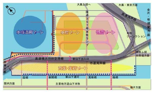
Border zone
It is located at the point of contact between cities and ports, and has the advantage of being able to locate various functions.
A large number of visitors come through land use conversion of landfills and existing land, aiming to create a bustling human-scale cityscape.
We aim to pass on the history of the region, such as locks that retain the memory of the former storage yard, and create a waterside space where you can feel the water.
We aim to form a pedestrian network in cooperation with surrounding areas such as the border line promenade.
Water area utilization zone
Located in the inner waters of Yokohama Port, it has unique features, such as the Bay Bridge being seen from the close.
The quiet and open space, which was once used as a raft pool in a storage yard, has great potential for its use and utilization in cooperation with the surrounding promenade plan and land use plan.
Logistics Zone
It is located at the base of Honmoku Wharf, the core of Yokohama Port.
Directly connected to the expressway network, it is also close to Daikoku Wharf and Minami Honmoku Wharf, which are logistics bases in Yokohama Port.
With the development of National Route 357, the connectivity with Daikoku Wharf will be further enhanced via the Bay Bridge.
Logistics facilities will be integrated in response to various facility demands, including port logistics.
Commercial and Business Zones
Located at the southern tip of the central coastal area, adjacent to Yamashita and Kannai-District, there are Motomachi, Chinatown, Yamashita Park and Harbor View Park (Minato-no-Mieru Oka Koen) nearby.
In this area, there were many port-related facilities such as logistics warehouses, but we will convert land use to areas where bustling commercial and business facilities are located, taking into account the landscape of the port such as canals.
By city planning, the border line promenade and sidewalk-like open space will be used as district facilities, and a pedestrian network will be formed with the surrounding area.
Inquiries to this page
Port and Harbor Bureau Yamashita-Futo Redevelopment Coordination Office, Yamashita-Futo Redevelopment Coordination Division
Telephone: 045-671-7312
Telephone: 045-671-7312
Fax: 045-550-4961
Email address: kw-yamashita@city.yokohama.lg.jp
Page ID: 215-910-701


