


- Yokohama-shi Top Page
- Izumi Ward Top Page
- Introduction of the ward
- Overview of Izumi Ward
- Location and terrain
Here's the text.
Location and terrain
Last Updated July 31, 2024
Position
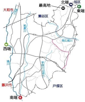
Izumi Ward is located in the southwestern part of Yokohama City, adjacent to Asahi Ward, Seya Ward and Totsuka Ward. In addition, it borders Yamato City and Fujisawa City across the Sakaigawa and Aizawa Rivers flowing through the city border. The Izumi Ward Office is located at 139 degrees 29 minutes 19 seconds east longitude and 35 degrees 25 minutes 04 seconds north latitude.
The eastern end of the ward is Midorien 7-chome and the western end is Kamiida-cho. The east-west distance is about 6.0 km, the southern end is Shimoiida-cho, the northern end is Midorien 7-chome, and the north-south distance is about 7.8 km.
Terrain
Izumi Ward covers an area of 23.56 square kilometers, accounting for 5.4 percent of the entire city of Yokohama (435.29 square kilometers), the tenth largest in the city.
The Sakaigawa and Aizawa rivers flow at the border of Fujisawa City and Yamato City, and the Izumi River, Akuwa River, and Udagawa flow in the ward. All three rivers flowing through the ward are tributaries of the Sakaigawa River, and Izumi Ward is included in the basins of the Sakaigawa River. In addition to rivers, Izumi Ward has abundant underground water veins, large number of springs, and rich water. Topographically, rivers form terraces on gentle hills and change.
Inquiries to this page
Izumi Ward General Affairs Department Ward Administration Promotion Division
Telephone: 045-800-2337
Telephone: 045-800-2337
Fax: 045-800-2506
Email address: iz-kusei@city.yokohama.lg.jp
Page ID: 206-078-433


