


- Yokohama-shi Top Page
- Disaster prevention and emergency services
- Disaster Prevention and Disasters
- Materials, data, plans, ordinances
- Materials and Data
- Various statistical surveys on earthquakes, etc.
- active fault Basic Survey Report on Yokohama City Area
Here's the text.
active fault Basic Survey Report on Yokohama City Area
Last Updated September 9, 2022
Purpose of the Survey
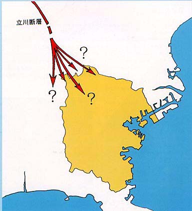
At present, the existence of active fault has not been confirmed in Yokohama.
However, there are frequent occurrences of micro-quakes near the border with Kawasaki City, and steps are presumed to be located in the depths offaultactive fault, Tachikawa.
Such data suggest that Tachikawa fault may extend to the city of Yokohama.
For this reason, we conducted a survey on the presence or absence of active fault in the Yokohama city area.
History of the Survey
Tachikawa fault is a active fault that stretches from Musashimurayama, Tokyo in Kitakata, Yokohama, from Tachikawa to Kunitachi, from northwest to southeast.
Previous studies suggest that Tachikawa fault generates a magnitude Class 7 earthquake approximately once every 5,000 years. The southern end of Tachikawa fault is located near the Tama River in Kunitachi City.
To find active fault, we look at aerial photographs, find small steps in the topography, and estimate active fault from its continuity, but the topography of Yokohama City Castle has been modified due to construction and other factors, so fine terrain cannot be read.
On the other hand, universities and others previously generated an artificial earthquake and explored the geological structure deep underground from the way the waves were transmitted, and it was reported that there was a step in the old stratum near 5 to 7 km deep in Yokohama City. Was. This step is located on the extension of Tachikawa fault.
Gravitational abnormalities may be observed around fault.
Gravitational force is often thought to be the same everywhere on Earth, but it actually varies slightly depending on the location. If there is a substance heavier than the surrounding area underground, the gravity on the surface will be larger than normal, and if there are light substances, it will be smaller. Therefore, when a heavy stratum deep underground rises to a shallow place due to the fault movement, a gravity value larger than normal is observed on the surface.
In order to clarify the steps of the stratum underground, we organized abnormal gravity (differences from standard values) measured on the surface of thefault around Yokohama and created a distribution map (Figure 1). This gravitational difference zone extends in the southeast direction and appears to reach Yokohama City.
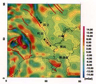
Figure 1 Distribution Map
Based on such data, we conducted the survey shown in the next section.
Method and Results of the Survey
The fault survey was conducted in cooperation with Kawasaki City. Kawasaki City conducted an earthquake exploration by anti-shooting method targeting the deep underground part. Yokohama City conducted shallow reflection and gravity exploration in shallow areas. Figure 2 shows the location of each survey.
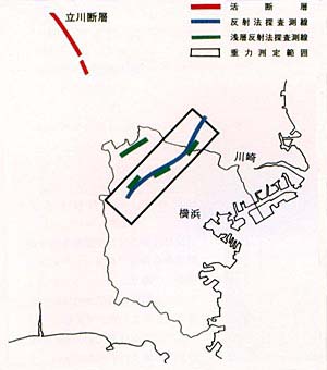
Figure 2 Survey Location Map
(1) Gravitational Exploration
Analysis using existing gravity data showed that the gravitational difference zone extended to Yokohama city area on an extension of Tachikawa fault. In Yokohama City, approximately 1,500 gravitational measurements were taken in the range of 5 km wide and 20 km long from Takatsu-ku, Kawasaki-shi to Asahi-ku, Yokohama. As a result (Figure 3), the distribution of abnormal gravity similar to the existing gravity data analysis results was also observed.
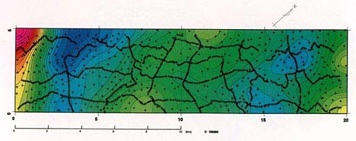
Figure 3 Gravitational Measurement Results
(Gravity abnormal distribution map)
(2) Earthquake exploration by reaction method
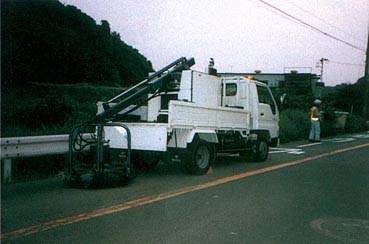
This was done by Kawasaki City, and the vibrations that were vibrationed from the ground surface and reflected in the underground stratum were captured by seismometers to explore the geological structure of the underground. Figure 4 shows an overview of earthquake exploration by anti-shooting method.
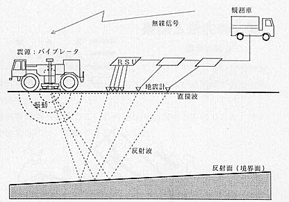
Figure 4 Overview of Earthquake Exploration by Anti-Shooting Method
The re-shooting method exploration was carried out on a sideline of about 15 km from Noge, Setagaya-ku, Tokyo, across Kawasaki City, and through Kohoku New Town to Kamikawai-cho, Asahi-ku.
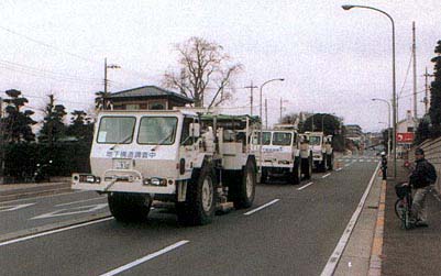
Status of re-injection exploration
In the reflection exploration results (Fig. 5), the white and black stripes show the reflective surface. The reflective surface is thought to represent differences in stratum and geology.
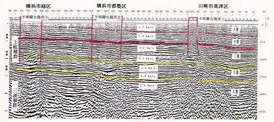
Figure 5 Anti-Shooting Exploration Results
Figure 6 shows the results of a reactionary exploration conducted at Nojima fault, which was active in the Hyogoken-Nanbu Earthquake. The deviation of the reflective surface is clearly visible. According to the results of the Yokohama city area, continuous reflection surfaces are observed in shallow places (a shallow depth of about 1500m). This indicates that the stratum is continuous and there is no fault. However, there are three places where the reflected waves are disturbed and the continuity is unclear. Here we cannot judge whether fault exists or not. For this reason, we conducted a more accurate shallow reflection method for these three locations.
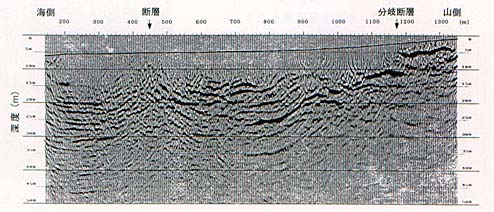
Results of Anti-Shooting Exploration at Nojima fault
(3) A shallow reflection method
The principle of shallow reflection exploration is the same as that of counter-injection exploration, but by shortening the wavelength of vibration, it obtains accurate data in the shallow part. The search locations were three locations where data was unclear during the anti-injection exploration. As a result of the shallow reflection probe (Figure 7), the reflective surface is continuous and there is no fault.
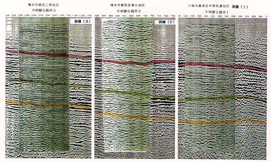
Figure 7 Results of shallow reflection method exploration
The shallow reflection method was also conducted in Aoba Ward, the northern end of Yokohama City, with a length of 4 km. This is to confirm that Tachikawa fault has not reached Yokohama by conducting a survey at the northern end of Yokohama, close to Tachikawa fault.
Investigation status of shallow reflection method
As shown in Figure 8, the reflection surface is continuous and there is no fault.
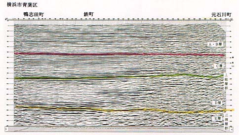
Figure 8 Results of shallow reflection method exploration at the northern end of Yokohama City
Does Tachikawa fault extend to Yokohama city area?
The results of previous surveys of artificial earthquakes and gravitational surveys suggest that Tachikawa fault may extend to Yokohama. However, the results of anti-injection exploration and shallow-injection exploration revealed that the formations distributed in shallow areas are continuous. According to the survey, since the Kazusa Group, which began to accumulate about 1.5 million years ago, has not been displaced by faults, fault has not been active since about 1.5 million years ago, and Tachikawa fault, active fault, did not extend to Yokohama.
Acknowledgment
I would like to express my deep appreciation to the teachers of the committee for their guidance and cooperation in this work.
Committee teachers (titles omitted)
- Chairman
- Kenichi Kojima (Dean, Satoshi, Yokohama City University)
- Vice Chair
- Masayuki Kikuchi (Professor, Earthquake Research Institute, The University of Tokyo) (Visiting Professor, Faculty of Science, Yokohama City University)
- Committee members
- Yoshihiro Kinugasa (Principal Investigator, Geological Survey Institute, National Research Institutes)
Kazuo Seo (Professor, Graduate School of Science and Engineering, Tokyo Institute of Technology)
Saburo Midorikawa (Professor, Graduate School of Science and Engineering, Tokyo Institute of Technology)
Iwayo Matsuda (Professor, Faculty of Economics, Kanto Gakuin University)
Haruo Yamazaki (Professor, Faculty of Science, Tokyo Metropolitan University)
Inquiries to this page
Disaster Prevention Planning Division, Crisis Management Department, General Affairs Bureau
Telephone: 045-671-4096
Telephone: 045-671-4096
Fax: 045-641-1677
Email address: so-bousaikikaku@city.yokohama.lg.jp
Page ID: 643-446-274


