- Yokohama-shi Top Page
- Tsurumi Ward Top Page
- Introduction of the ward
- Overview of Tsurumi Ward
- History of Tsurumi Ward
- 9th: The Tsurumi River Bypass Project, which was more than 100 years ago
- 9th: Tsurumi River Bypass Plan (Part 1), which was more than 100 years ago.
Here's the text.
9th: Tsurumi River Bypass Plan (Part 1), which was more than 100 years ago.
Last Updated November 7, 2024
Tsurumi River and Kanagawa Ward
The Tsurumi River, which originates in Machida City, passes through Aoba Ward, Midori Ward, Tsuzuki Ward and Kohoku Ward, and Tsurumi Ward into Tokyo Bay. At first glance, the Tsurumi River and the Kanagawa Ward, which seem unrelated, were actually unknown.
The flood control safety of the Tsurumi River has increased!
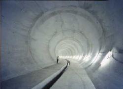
Over the course of 10 years, Yokohama City completed the Koseki Chiwaka Rainwater Trunk Line, a huge underground tunnel with a total length of about 7.9 meters and an inner diameter of 3.5 to 8.5 meters, in 1996. When 60 mm of rainfall was in the Tsurumi River basin, it is one of the Tsurumi River safety devices that take in some of the rainwater and store it underground, and gradually pump up and drain it to the sea. There is an exit at Kanagawa Sewage Treatment Plant, about 5 minutes from Higashi-Kanagawa Station.

Currently, the Tsurumi River Multipurpose Yusuichi is under construction in the area around Yokohama International Stadium (approximately 840,000 square meters) to temporarily store rainwater and water from the Tsurumi River during heavy rains. Since it stores a total storage capacity of 3.9 billion liters of water, the building in Tsurumi River Multipurpose Yusuichi has a high base and has a structure that can store water. When the flood subsides, it gradually flows from the drainage gate to the Tsurumi River. This project is being promoted by the Ministry of Land, Infrastructure, Transport and Tourism.
The Tsurumi River has long been famous for its rampage river. Until recently, we have managed to deal with concrete embankments and rivers, but the urbanization rate has exceeded 80%, and when it rains almost all flowed from the sewer pipe to the Tsurumi River, and the water level rose about 2 meters in a short time. It was a situation that it would go up. Therefore, it is considered to temporarily store water in a large pond and a huge underground pipe, and it is finally moving toward realization.
According to history, farmers who suffered from the flood have built many times, thinking of flowing water from the Tsurumi River from a small desk to the sea of Kanagawa via Kishine and Rokukakubashi. I would like to look back on the history.
The villages along the river that have been suffering from floods
The Tsurumi River has little difference in height between the middle and lower capital from Futoo Bridge to the mouth of the river, and the tide is full every day, so it is blessed with boat transportation, and the downstream area where fresh water and seawater intersect is also blessed with fishing. However, due to the tide, the water of the river cannot be used for agricultural water, the right bank creates a reservoir in Tando, and the left bank distributes the water of the Tama River as two territorial waters to Shiota, Oda, and Wata like a net. I was making rice. The flood created fertile land and was blessed with fruit trees and vegetables.
On the other hand, the flood caused important rice to be flooded, and it was a series of applications for annual tribute reduction. It has long been said that "Don't marry Futoo." It is only until recently that a flat bottom boat was hung in a farmer's barn.
The villages of Kanagawa, blessed with water and rivers
The villages of Kanagawa were not suitable for fields because there were many mountain slopes and there was no water on the ground, so they could only run agriculture in very small areas along the waterfall river and the Irie river.
Regarding the use of rivers, various methods such as Sekai (changing the flow route), diversion channels, and irrigation water have been devised and practiced earlier, but for farmers who have few opportunities to see information, The Shinkawa and the diversion plan described later seemed to be no one except for inconvenience, and the water of the Tsurumi River flows over the shore hill, which is the watershed today.
Inquiries to this page
Tsurumi Ward General Affairs Department Ward Administration Promotion Division
Telephone: 045-510-1680
Telephone: 045-510-1680
Fax: 045-510-1891
Email address: tr-kusei@city.yokohama.lg.jp
Page ID: 138-254-169


