


- Yokohama-shi Top Page
- Tsurumi Ward Top Page
- Disaster Prevention and anti-crime program
- Disaster Prevention and Disasters
- Disaster prevention maps and hazard maps
- View each map with "Catalog Pocket" (multillingual translation / speech-to-speech function)
Here's the text.
View each map with "Catalog Pocket" (multillingual translation / speech-to-speech function)
Last Updated September 26, 2023
Catalog Pockets
Tsurumi Life / Disaster Prevention Map and each hazard map correspond to catalog pockets.
Catalog Pocket is a service that allows you to browse publicity materials from your smartphone or PC. By converting public relations materials into e-books, the text in the article will pop up and make it easier to read, as well as functions such as voice reading functions and multilingual automatic translation can be used.
<Response language>
Japanese, English, Korean, Traditional Chinese, Simplified Chinese, Thai, Portuguese, etc.
Spanish, Indonesian, Vietnamese
Please refer to the public relations paper browsing service "Catalog Pocket" for details on how to use it.
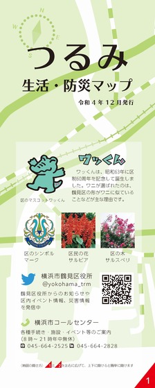
Tsurumi Life and Disaster Prevention Map
The Tsurumi Life and Disaster Prevention Map contains information on disaster prevention such as major public facilities in Tsurumi Ward, public facilities, famous places in the ward, and evacuation sites in the event of an earthquake.
Read "Tsurumi Life and Disaster Prevention Map" in catalog pocket (outside site)
Flood Hazard Map (Flood, Inland Water, high tides)
The Flood Hazard Map is a compilation of three hazard maps, flood, inland water, and high tides.
Read “Inundation Hazard Map” in catalog pockets (outside site)
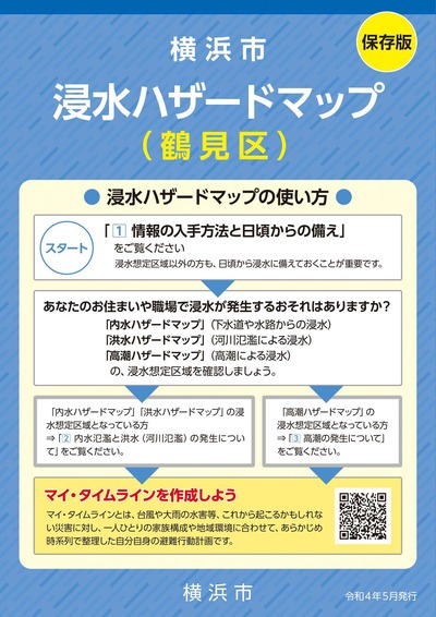
About three types of hazard maps
・Flood Hazard Map
Based on the Flood Control Law (Article 15 of the Flood Control Law, Article 11 of the Enforcement Regulations of the Act), in order to ensure smooth and prompt evacuation during floods, flooding is expected when rivers are flooded due to rainfall of the largest possible scale etc. Information such as evacuation shelters is displayed in the flood inundation area map that displays the assumed flood inundation area and the assumed water depth.
・Inland water hazard map
It is a map that summarizes various information such as the area where inundation from sewer pipes and waterways is expected and the depth of inundation due to the largest possible rainfall (153 mm per hour).
The inland water hazard map of Yokohama City is not based on the Flood Control Law, but it is created to use it for smooth evacuation actions against flooding and raising awareness of disaster prevention during normal times.
・high tides Hazard Map
In accordance with the Flood Control Law (Article 15 of the Flood Control Law and Article 11 of the Enforcement Regulations of the Act), information on evacuation centers and other facilities is shown in the high tides inundation area map, which shows the estimated depth of water in the event of a high tides of the largest possiblehigh tides,high tides, and other areas.
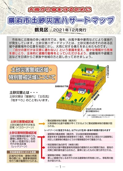
Earth and sand disaster hazard map
The landslide hazard map shows areas where there is a risk of damage if a landslide occurs due to heavy rain associated with the torrential rainfalls during the rainy season or typhoon. It was created so that citizens can take appropriate actions such as evacuation.
Read "Landslide Hazard Map" in catalog pockets (outside site)
Inquiries to this page
Tsurumi Ward General Affairs Department Ward Administration Promotion Division
Telephone: 045-510-1680
Telephone: 045-510-1680
Fax: 045-510-1891
Email address: tr-kusei@city.yokohama.lg.jp
Page ID: 349-494-475


