


Here's the text.
Walking
Last Updated October 31, 2024
Introduction of Kanagawa Ward Walking Map
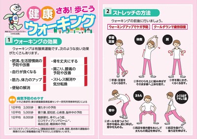
Walking is aerobic exercise that anyone can easily do.
The highlight of Kanagawa Ward is "Well! Please make use of "Let's Walk Health Walking Map" for your health promotion!
●Distribution location
1 Ward Office Health and Welfare Division (308 window on the 3rd floor of the main building)
Community care plaza in 2 wards
NEW! [Revised Walking Map] A course that can be easily walked in about 30 minutes
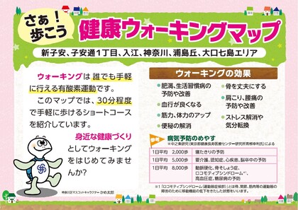
■Shinkoyasu, Koyasu-dori 1-chome, Irie, Kanagawa, Urashimaoka, Oguchi Nanashima area
A Taro Urashima Course (PDF: 1,626KB) (Approx. 2km around Kanagawa Shinmachi Station)
B Course of seasonal flowers and park tours (PDF: 1,629KB) (approximately 3km around Shinkoyasu Community Care Plaza)
■Sugeta, Hazawa area
Sugeta Course Park and Nature Enjoyment Course (PDF: 3,412KB) (about 2 km around housing complex, West Sugeta)
Hazawa Course Aiming for Hazawa Yokohama National University Station (Hazakoku) Course (PDF: 5,707KB) (Hazawa Sports Hall-Hazawa Yokohama National University Station approximately 2.5km)
※Maps are also distributed at the Hazawa Sports Hall.
"Well! "Let's Walk Healthy Walking Course" Map 6 Courses
| Course name | |
|---|---|
Distance: Approx. 4.9km |
|
"Shinkoyasu / Koyasu-dori 1-chome / Inlet / Kanagawa course along a flat railway" (PDF: 1,448KB) |
Distance: Approx. 6.2km |
"Matsumi / Nishiterao course over Iriegawa murmuring green road" (PDF: 1,413KB) |
Distance: Approx. 4km |
"Mitsuzawa to Former Tokaido Kami Nagawa-juku Course" (PDF: 1,397KB) |
Distance: Approx. 7.3km |
"Katakura, Sanmai, Kandaiji course where you can enjoy seasonal flowers and trees" (PDF: 1,375KB) |
Distance: Approx. 5.1km |
“Green Field Road Course around Hazawa and Sugeta” (PDF: 1,478KB) |
Distance: Approx. 6.8km |
■[Health Information] The back of the walking map
■Public information Yokohama Kanagawa Ward February, 2020 issue (PDF: 387KB)
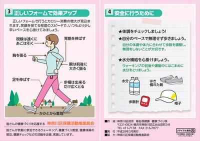
Information on how to walk to bring out the effects and effects of walking.
Please use it as a reference when walking.
Walking booklets in the city and other maps
Kanagawa Ward offers several booklets and maps useful for walking.
Please use it according to the mood and purpose of the day!
Click here → Walking map of Kanagawa Ward
Kanagawa Ward! Let's walk healthy walking steps record sheet
Kanagawa Ward's original step count record paper is created.
Make use of the product to record the number of steps every day and promote health.
Step count record paper (Excel: 201KB)
Yokohama City is aiming to be the best healthy life expectancy in Japan, and is promoting the creation of a system that allows people to enjoy health while having fun in their daily lives.
Various businesses
■Yokohama Walking Point
■Yokohama Senior Volunteer Point
You may need a separate PDF reader to open a PDF file.
If you do not have it, you can download it free of charge from Adobe.
![]() To download Adobe Acrobat Reader DC
To download Adobe Acrobat Reader DC
Inquiries to this page
Kanagawa Ward Health and Welfare Division
Telephone: 045-411-7138
Telephone: 045-411-7138
Fax: 045-316-7877
Page ID: 905-520-173


